
>Bath DIY Walking Tour Route Map <
Distance: 6.7 km (just over 4 miles); Duration: 2-8 hours
Bath DIY Walking Tour
This circular DIY Walking Tour of Bath is 6.7 kilometres long (just over 4 miles). And as “normal” walking speed is around 7kph/4mph, this is a very easy 2-3 hour walk (allow for a whole day though – as this will give you plenty of time to visit some of the best attractions in Bath).
And, as this Bath DIY Walking Tour route is indeed circular, it can be made in either direction (and as the park section is midway, then you should arrive there at the same time regardless of which direction you travel.
In this example though, you will be guided around Bath in a clockwise direction.
But, being a circular route, you can start/end the Bath DIY Walking Tour at any point (depending on the location of your central Bath hotel perhaps?).
As most visitors to Bath will arrive at Bath Spa Train Station however, I will use there as the start/end point.
Along the way, you will pass (and visit?) the following Bath attractions:
Bath Spa Train Station > Roman Baths > Bath Abbey > Theatre Royal > Queen Square > Jane Austen Centre > Royal Victoria Park > Bath Botanical Gardens > No. 1 Royal Crescent > The Circus > Museum of East Asian Art > Assembly Rooms > Victoria Art Gallery > Pulteney Bridge > Holburne Museum > Parade Gardens > Sally Lunn’s Eating House & Museum > and finally returning to Bath Spa Train Station.
As well as these popular visitor attractions in central Bath, the route of the Bath DIY Walking Tour also passes numerous restaurants, cafes and bars.
Also, because it’s actually a DIY walking tour of Bath, you can take it at your very own pace; stopping for a coffee/snack/drink where, when, and for as long as you like; lingering at the attractions of Bath that interest you (and speeding past those that don’t).
So if you were to simply rush round without stopping, you could easily complete the entire journey in around 2-3 hours. However, I would recommend taking a full day to complete this circular route from Bath Spa Train Station and back.
Bath DIY Walking Tour - Directions:
These are very thorough walking directions – you shouldn’t be getting lost in Bath when following this guide.
However, I definitely recommend that you follow the Google Streetview route of the entire Bath DIY Walking Tour first, from the comfort of your own home before you even head to Bath, as this will allow you to better visualise the entire route before you arrive.
START: Bath Spa Train Station
[MAP]:
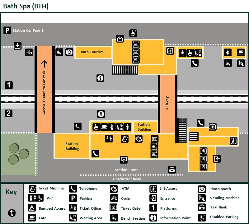
[IMPORTANT: Bath Spa Train Station has separate passenger exits and entrances: this will be important to know, when you return to Bath Spa at the end of this DIY Walking Tour of Bath].
There are also toilets (including an accessible toilet) on the main concourse at Bath Spa Station, which you should make use of (however, if you plan to visit Bath Abbey, you’ll be there in less than 10 minutes time – and there are toilets, including a much larger accessible toilet and a Changing Places toilet, there too).
As soon as you exit the station, immediately turn RIGHT, and head towards the main road (Dorchester Street), but don’t go too far – just far enough so that you remain at street level.
When you reach the main pavement, turn LEFT, and head for the light-controlled pedestrian crossing, which will take you across Dorchester Street.
After crossing here, continue STRAIGHT AHEAD, along the pedestrianised St.Lawrence Street.
At the end of St.Lawrence Street, turn LEFTISH into Southgate Square (but keep to the RIGHTHAND side).
Once you enter Southgate Square, head to the right, and continue along the pedestrianised continuation of St.Lawrence Street, until the end of the street, where you should continue STRAIGHT AHEAD along the RIGHTHAND pavement of Stall Street, until it becomes pedestrianised again (just after you pass the accessible Roman Baths and Pump Room on your RIGHT – the visitor entrance is around the NEXT corner on your RIGHT though).
Roman Baths & Pump Room
[MAP]:
To reach the Visitors Entrance to the Roman Baths, turn RIGHT just AFTER passing the main Roman Baths building, into the colonnaded entrance to Abbey Churchyard. On your RIGHT, you will see the visitor entrance to the Roman Baths.
The Roman Baths are among the best-preserved ancient Roman sites in northern Europe and are the most famous attraction in Bath. Built around Britain’s only naturally occurring hot springs, they offer a remarkable glimpse into Roman life nearly 2,000 years ago.
And after visiting the Roman Baths, enjoy the classical music of the Pump Room Trio, while you sip tea in the Pump Room Restaurant – a musical tradition that’s lasted over 300 years.
Plan your visit via the official Roman Baths website.
Accessibility at the Roman Baths (official website).
After visiting the Roman Baths, head RIGHTISH to the visitor entrance of Bath Abbey.
Bath Abbey
[MAP]:
Famous for its large stained-glass windows, Bath Abbey is one of the finest examples of Perpendicular Gothic architecture in England, and a landmark at the heart of the historic city of Bath. Standing beside the Roman Baths, it has been a place of worship for more than 1,200 years.
Plan your visit via the official Bath Abbey website.
Accessibility at Bath Abbey (official website).
On leaving Bath Abbey, continue STRAIGHT AHEAD, and pass through the colonnaded exit of Abbey Churchyard again.
After passing through the columns, immedately turn RIGHT, and continue along the pedstrianised Stall Street.
At the end of Stall Street (when you reach the road), turn LEFT, and continue along the LEFTHAND pavement of Westgate Street. Follow Westgate Street as it turns RIGHT and becomes Saw Close.
Continue up Saw Close, still on the LEFTHAND pavement, until you arrive at the Theatre Royal.
Theatre Royal
[MAP]:
Known for attracting high-profile productions before they transfer to London’s West End, the Bath Theatre Royal is one of the oldest and most prestigious working theatres in the United Kingdom. Opened in 1805, it has hosted generations of celebrated actors and remains a major cultural venue in Bath (previous performers include Peter O’Toole, Judi Dench, Ian McKellen, and Benedict Cumberbatch).
Plan your visit via the official Theatre Royal website.
Accessibility at the Theatre Royal Bath (official website PDF).
Continue past the Theatre Royal, and continue STRAIGHT AHEAD, along the LEFTHAND pavement of Barton Street.
Continue along Barton Street until you see the leafy Queen Square diagonally to your left.
Turn LEFT here, and you will immediately see a dropped kerb on your RIGHT (there is a corresponding dropped kerb on the opposite/Queen Square side of the road here too).
Turn LEFT after crossing here, and continue along until you see the central entrance to Queen Square on your RIGHT.
Queen Square
[MAP]:
Designed as a formal square surrounded by elegant Georgian townhouses, Queen Square is one of Bath’s most important Georgian spaces and a key part of the city’s celebrated 18th-century urban design. It was the first major architectural project in Bath by the renowned architect John Wood the Elder. Historically significant – as it introduced the grand Georgian planning principles that would later culminate in Bath’s most famous architectural ensembles.
At the centre of the square stands a decorative obelisk erected in 1738 to commemorate the royal family. It serves as a focal point within the landscaped gardens.
Once you reach the obelisk in the centre of Queen Square, turn RIGHT, and head to the exit.
After leaving the Queen Square park, immediately turn LEFT and continue STRAIGHT AHEAD until you see a light-controlled pedestrian crossing at the corner of Queen Square.
After crossing here, you will see yet another light-controlled pedestrian crossing on your RIGHT (which crosses Gay Street). As this only leads to the mostly inaccessible Jane Austen Centre, and as you would have to re-cross here after the visit anyway, wheelchair users should just ignore this paragraph, and the following 3 paragraphs too – and just remain on this side of Gay Street. For those who have crossed here though:
At the end of this second crossing, turn LEFT, and continue up the righthand pavement of Gay Street for a few metres, until you see the Jane Austen Centre on your RIGHT.
Jane Austen Centre
[MAP]:
The Jane Austen Centre is one of Bath’s most popular literary attractions, dedicated to the life, works, and the Regency-era world of Jane Austen. A fun and immersive experience, particularly because of its actors, costumes, and Bath-focused interpretation of Jane Austen’s life.
The annual Jane Austen Festival is the world’s largest and longest-running celebration of Jane Austen, held annually in Bath – a city closely associated with Jane Austen’s life and novels. The festival began in 2001 and has grown into a major international event attracting thousands of visitors from around the world.
Plan your visit via the official Jane Austen Centre website.
Accessibility at the Jane Austen Centre in Bath: Although a portable ramp is available, on request (to pass the steps at the main entrance), there is no lift inside this Georgian building. Which means there is no access to the toilets (downstairs), to the Talk Room (First Floor), or to the Regency Tearoom (Second Floor). So wheelchair users should do no more than take a photograph when passing on the other side of Gay Street.
For walkers who did visit the Jane Austen Centre though, on exiting the Jane Austen Centre after your visit, turn LEFT, and retrace your steps down Gay Street, and re-cross the same pedestrian crossing as before.
After re-crossing the light-controlled pedestrian crossing, turn RIGHT, and continue up the LEFTHAND pavement of Gay Street until the very first turning on your LEFT (into Queen’s Parade Place).
Instead of immediately turning here though, cross the road first, and THEN turn LEFT – following the RIGHTHAND pavement of Queen’s Parade Place (it is important to cross here, as there are dropped/flattened kerbs here – and there are none later on).
After passing the steps leading up to the “Gravel Path”, cross the road in front of you (Royal Avenue), and turn RIGHT, following the LEFTHAND pavement of Royal Avenue.
Accessibility Warning: There are no dropped, or flattened, kerbs here (so you may need to reverse down onto the roadway with the help of an assistant). The pavement on this nearside is quite shallow though, and on the other side of the road there is no issue at all (as you can simply use the garage driveway as a wheelchair ramp).
Royal Victoria Park
[MAP]:
Covering approximately 57 acres (23 hectares) of landscaped gardens, lawns, woodland, and recreational areas, Royal Victoria Park is Bath’s largest and most popular public park (opened in 1830, it was named in honour of the then 11-year-old Princess Victoria, who officially opened the park before ascending to the throne).
While Bath is famous for its Roman and Georgian heritage, Royal Victoria Park offers a different side of the city: open green space, gardens, and excellent views. It pairs especially well with a visit to the Royal Crescent and provides a relaxing break from sightseeing in the city centre.
Popular for picnics, walking, sports, and family outings.
Plan your visit via the official Royal Victoria Park website (the park is managed by Bath and North East Somerset Council).
After passing through the entrance to the Royal Victoria Park, take the paved path on your LEFT.
This path takes you past the Royal Pavilion Cafe (which is wheelchair accessible, and also has an accessible toilet), and ends up rejoining the main pavement. Continue along this LEFTHAND pavement until you see more paved paths heading off to your LEFT.
Follow the second paved path through the park, following it as it bends right and returns to Royal Avenue at the junction with Marlborough Lane.
After passing through the gate here, you will find dropped kerbs on your LEFT, which will take you across Marlborough Lane.
At the end of the crossing, continue STRAIGHT AHEAD, along the lefthand pavement of Royal Avenue, passing the Victoria Obelisk (on your RIGHT, in the centre of the road), until you see another paved path on your LEFT which leads to the Royal Victoria Park Play Area (but more importantly, also leads to an accessible public toilet).
Follow this path until it eventually rejoins the main road (although there are steps back up to the main road/pavement here, there is also a step-free ramp).
At the top of the steps/ramp, cross the main road in front of you (there are dropped kerbs here), turn LEFT after crossing the road, and continue along the RIGHTHAND pavement of Royal Avenue until it passes to the RIGHT of the trees that line Royal Avenue (you’ll still be walking in the same direction, parallel to the road, just with trees between you and any road traffic now). The surface of the path is hard packed gravel/earth.
Continue following this path (always adjacent to the road), until you arrive at the entrance to the Botanical Gardens.
Bath Botanical Gardens
[MAP]:
Established in 1887, the Bath Botanical Gardens are among the finest free botanical gardens in southwest England. A peaceful setting with a diverse collection of plants from around the world (more than 8,000 plant specimens across themed collections, in landscaped beds).
Plan your visit via the official Bath Botanical Gardens website (the Botanical Gardens are also managed by Bath and North East Somerset Council).
Accessibility: The Bath Botanical Gardens are fully accessible, with tarmac paths around the gardens.
After visiting Bath’s Botanical Gardens, leave by the same exit/entrance that you first arrived at, and retrace your steps to where the path rejoins the main pavement/road again.
However, instead of walking along the pavement ahead of you, turn LEFT, and follow the path away from the road, and deeper into Royal Victoria Park, until you come to the SECOND path on your RIGHT (this is actually the first wide path).
Accessibility information: This is a gravel path, and the gravel is quite loose. Powerchairs should have no problem traversing it though (and the gravel path only lasts for about 50 metres or so, so it won’t be too much of a battery-drain). However, manual wheelchair users may need assistance (and if it still proves too much work, then you should simply continue along the main paved path, and follow the road around to the RIGHT until you reach the LEFTHAND turning into Cow Lane). Turn LEFT here, and head down Cow Lane.
If you have followed the path however, when you reach the end of the path, cross the road STRAIGHT AHEAD, and head down Cow Lane on the other side of the road.
At the end of Cow Lane, remain on the roadway, and cross the main road (Marlborough Buildings) diagonally/slightly leftwards. Turn RIGHT onto the path, which runs directly opposite Royal Crescent (about halway along the path here is a fantastic viewpoint/photograph opportunity of the entire Royal Crescent).
Royal Crescent
[MAP]:
Continue to follow the path here (with Royal Crescent on your left), and take the very first turning on your LEFT, and head up the footpath towards Brock Street and the Royal Crescent.
When you reach the top of the path, and Brock Street, head DIAGONALLY LEFT towards No.1 Royal Crescent (the pavement on this near side is almost level with the road surface, and on the other side, there is a dropped kerb by No. 1 Royal Crescent (at the junction with Upper Church Street).
No.1 Royal Crescent
[MAP]:
No. 1 Royal Crescent is one of Bath’s premier museums and offers a fascinating glimpse into life in an affluent Georgian household. Situated at the eastern end of the famous Royal Crescent, the house has been carefully restored and furnished to reflect the period between 1776 and 1796. Behind the house is a restored Georgian garden designed to reflect late-18th-century tastes, providing a pleasant contrast to the grand interiors.
Important Accessibility Information: There are steps leading up to the main entrance. However, there is also an accessible entrance to No.1 Royal Crescent – via the entrance on the right (the entrance to the Museum Shop). There is also a separate step-free route around the interior of BOTH buildings, using an accessible lift. which includes: the Dining room, the Parlour, the Gentleman’s Retreat, the Housekeeper’s Room, the Servants’ Hall, the Shop and the Andrew Brownsword Gallery (sadly, the step-free route misses out the Gentleman’s Bedroom, the Ladies Bedroom, the Withdrawing Room and the Kitchen).
Plan your visit via the official No. 1 Royal Crescent website.
Accessibility at No. 1 Royal Crescent (official website).
When leaving No. 1 Royal Crescent , turn LEFT, cross the end of Upper Church Street at the corner (there are also dropped kerbs on both sides here), and head down the LEFTHAND pavement of Brock Street (ahead of you, you will see the huge trees in the centre of The Circus).
The Circus
[MAP]:
When you reach the end of Brock Street, turn LEFT, and walk around one quarter of The Circus, turning LEFT again at the very first turning (into Bennett Street).
Remain on this LEFTHAND pavement, and after a few metres, you will see the entrance to the Museum of East Asian Art on your LEFT.
Museum of East Asian Art
The Museum of East Asian Art (MEAA) is one of Bath’s hidden gems, and is the only museum in the UK dedicated solely to the arts and cultures of East and Southeast Asia. Housed in a restored Georgian townhouse near the Circus, it contains more than 2,000 objects spanning over 7,000 years of history, including one of the UK’s most comprehensive collections of Chinese jade, plus ceramics, bronzes, lacquerware, bamboo carvings, and metalwork.
Plan your visit via the official Museum of East Asian Art website.
Accessibility at the Museum of East Asian Art (official website).
Important Accessibility Information: There is a small step at the entrance of the Museum of East Asian Art. It’s not a huge step though, so with a bit of assistance, most wheelchairs will be able to pass it (however, a portable ramp is also available on request). Your main issue may be the interior lift though (which makes every floor accessible). The lift is not huge (just 73cm x 110cm). On the plus side, assistants have free entry.
On leaving the Museum of East Asian Art, cross Bennett Street DIRECTLY AHEAD/SLIGHTLY LEFTISH (there are flattened kerbs on the corner here, and on the opposite side of Bennett Street there is a flattened kerb too, if needed).
Once across Bennett Street, turn LEFT, and immediately turn RIGHT (or just continue STRAIGHT AHEAD if you have used the lowered kerb), and head for the entrance to the stunning Bath Assembly Rooms on your LEFT.
Bath Assembly Rooms
The Bath Assembly Rooms are currently closed for refurbishment, but the National Trust (who now own the Assembly Rooms) expect them to reopen in 2027).
For now though, continue past the entrance, then turn LEFT and continue along the LEFTHAND pavement of Alfred Street until you reach the end of the Assembly Rooms building.
Turn RIGHT here, and cross Alfred Street (there are dropped kerbs here if needed).
After crossing Alfred Street here, continue STRAIGHT HEAD, down Bartlett Street (it is important to keep to the LEFTHAND side here), and continue on the LEFTHAND pavement until it ends at the junction with George Street.
Cross the end of Bartlett Street to the RIGHT, (there are dropped kerbs here), and you will immediately see a pedestrian crossing on your LEFT.
After crossing George Street here, turn RIGHT at the end of the crossing, and then turn LEFT into Milsom Street.
Continue down the LEFTHAND pavement of Milsom Street until it starts curving left into New Bond Street.
Cross New Bond Street here (the kerbs are flattened), turning LEFT at the end of the crossing, and continue along the pedestrianised Burton Street.
At the end of Burton Street, turn LEFT into Upper Borough Walls, which is now mainly pedestrianised.
At the end of Upper Borough Walls, turn RIGHT into Northgate Street (there is a dropped kerb here, which will allow you to climb onto the pavement again).
Continue STRAIGHT AHEAD, and almost immediately you will see a pedestrian crossing on your LEFT, which will allow you to cross High Street in two stages (when you reach the island, turn slightly RIGHTISH, and continue across the second lane – the general traffic lane).
At the end of the second part of the crossing, turn LEFT, and head down the RIGHTHAND pavement of Bridge Street. After a few metres, and on your RIGHT, you will see the entrance to the Victoria Art Gallery (accessible).
Victoria Art Gallery
[MAP]:
The Grade II listed Victoria Art Gallery is Bath’s main public art museum, located right in the city centre near Pulteney Bridge. Over 1,500 artworks (paintings, sculpture, and decorative arts) , including works by Thomas Gainsborough, Walter Sickert, Gillian Ayres & Paul Klee.
Plan your visit via the official Victoria Art Gallery website.
Accessibility at the Victoria Art Gallery (official website).
On leaving Victoria Art Gallery, turn RIGHT, and continue down the righthand pavement of Bridge Street.
At the corner, you will see a light-controlled pedestrian crossing ahead of you (which crosses Grand Parade).
At the end of the crossing, continue STRAIGHT AHEAD/LEFTISH across Pulteney Bridge (it won’t feel like you’re actually crossing a bridge, as the completely level Pulteney Bridge is lined by buildings on both sides).
Pulteney Bridge
[MAP]:
Built between 1769 and 1774 to connect central Bath with the new Georgian developments on the opposite bank of the river, Pulteney Bridge is one of Bath’s most famous landmarks – a rare example of a bridge that is also a street lined with shops on both sides.
After crossing Pulteney Bridge, follow this RIGHTHAND pavement to the end of the street (passing around the RIGHTHAND side of Laura Place as you go).
At the end of the street (now called Great Pulteney Street), you will see a light-controlled pedestrian crossing ahead of you/to the right.
Turn LEFT at the end of the crossing, and you will see the entrance to the Holburne Museum on your RIGHT.
Holburne Museum
[MAP]:
Founded in 1882 from the collection of Sir William Holburne, the Holburne Museum was Bath’s first public art gallery – and is one of its most elegant museums, set in a striking Grade I listed Georgian building at the end of Great Pulteney Street. Housing over 9,000 objects, including: British portraits by artists like Thomas Gainsborough and Joshua Reynolds; Decorative arts: silver, porcelain, furniture, and sculpture; and Italian Renaissance paintings and European works from the 16th–18th centuries. There are also regularly changing exhibitions, often bringing major international works to Bath.
Plan your visit via the official Holburne Museum website.
Accessibility at the Holburne Museum (official website).
After visiting the Holburne Museum (which Bridgerton fans will have recognised instantly), retrace your steps as far as Pulteney Bridge again.
Instead of crossing as before though, turn LEFT into Grand Parade, and on your LEFT you will find an excellent viewpoint – with a view of Pulteney Bridge and the River Avon cascading over Pulteney Weir (there is an even better view from the end of Parade Gardens in a moment).
Follow Grand Parade as it sweeps RIGHT, then just as the road sweeps LEFT again, you will see the entrance to Parade Gardens on your LEFT. There are actually two gates here. Use the gate on the LEFT to access the gardens via steps; or use the one on the RIGHT for ramp access.
Parade Gardens
[MAP]:
A formal riverside garden in the heart of Bath, Parade Gardens overlook the River Avon and sit just below the city’s main historic centre. The gardens were developed in the 18th century as part of Bath’s Georgian leisure landscape.
Visitor’s Tip: The best time to visit is late afternoon or early evening when the light hits the river and Bath stone buildings, making the whole area glow. It’s especially photogenic in spring and summer when the gardens are in full bloom.
Plan your visit via the official Parade Gardens website (the gardens are maintained by Bath and North East Somerset Council).
When you exit the gardens via the same exit/entrance, turn LEFT, and almost immediately you will see a light-controlled pedestrian crossing which will take you across Orange Grove on your RIGHT.
After crossing the first stage, you will arrive at a central island. Turn LEFT here, where you will find the second part of the crossing. At the end of the second crossing. turn LEFT then RIGHT, and follow the pavement as it bends RIGHT into Terrace Walk.
Continue along Terrace Walk until you see the Abbey Hotel building in front of you – along the way, you will cross York Street (there are dropped kerbs here if needed).
When you do finally see the Abbey Hotel in front of you, turn RIGHT, into North Parade, and after a few metres you will see Sally Lunn’s Eating House and Museum on your RIGHT (the oldest house in Bath).
Sally Lunn's Eating House and Museum
[MAP]:
Sally Lunn’s Eating House is one of Bath’s most famous and unusual historic eateries — part historic tea room and restaurant, part museum, and a living piece of the city’s medieval past (Sally Lunn’s is housed in one of the oldest surviving houses in Bath, dating back to around the late 15th century).
Famous for the Sally Lunn bun – a large, light brioche-style bread served sweet or savoury.
Plan your visit via the official Sally Lunn’s Eating House website.
Accessibility at Sally Lunn’s Eating House:
Only the ground floor is wheelchair accessible. The museum (small) is down a flight of steps, and the toilets are upstairs (however, there is an accessible public toilet in nearby Parade Gardens).
It does get rather busy in Sally Lunn’s though.
After leaving Sally Lunn’s, continue RIGHT along the narrow North Parade Passage, until it opens out at Abbey Green.
Your destination at Abbey Green is the archway directly diagonally across to your LEFT. And, for walkers, there is no real difference in how you get there/pass the 220-year-old plane tree in the middle (however, wheelchair users should definitely take the pavement on your LEFT, the tree will then be on your RIGHT, and follow the pavement as it bends around to the archway. The pavement narrows/almost disappears on this side of the archway though, but there is a slightly lowered kerb which will take you down onto the cobbles. Pass through the archway on the road).
After passing through the archway, follow the road RIGHT, into Abbeygate Street, follow this to the end, and then turn LEFT into the pedestrianised Stall Street again.
From here, you will simply be retracing your steps back to Bath Spa Railway Station:
Continue until the end of Stall Street, take the second street on your LEFT (St.Lawrence Street), and follow it until the end, where it continues to your RIGHT, eventually ending at the same pedestrian crossing you used to start your DIY Walking Tour of Bath.
After crossing here, turn LEFT and head back towards Bath Spa Railway Station.
This is where there is an ever-so-slight difference though:
Bath Spa Railway Station has different doors for the entrance and exit. So continue to the LEFT of the station building, where you will find the main entrance to Bath Spa Railway Station.
Back to where you started at Bath Spa Train Station, but at the passenger entrance.
YOUR BATH DIY WALKING TOUR NOW ENDS
Bath Guide Books & Bath Maps
Powered by Waterstones


If this Bath DIY Walking Tour information has helped you in any way, please consider making a small donation via Ko-Fi.
Your support enables me to maintain and create even more of these informative DIY Walking Tour/accessibility articles.
Alternatively, and at no additional cost to yourself at all, do your Online Shopping via www.ataxia.scot (I’ll also tell you what Sales are on at the moment too – so it might end up saving you a few pounds – spending-money for Bath perhaps?).
Thank you SO much for your very kind support – and have a great time in Bath!